Back Ashford District CEB Bwrdeistref Ashford Welsh Borough of Ashford German Municipio de Ashford Spanish Ashford (borough) French Ashford (borough) Italian 애슈퍼드구 Korean Ešforda (boro) Latvian/Lettish Ashford (district) Dutch Ashford (Kent) NB
Borough of Ashford | |
|---|---|
 Aerial view of Ashford Designer Outlet | |
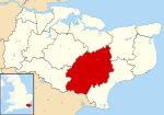
 Ashford shown within Kent | |
| Sovereign state | United Kingdom |
| Constituent country | England |
| Region | South East England |
| Non-metropolitan county | Kent |
| Status | Non-metropolitan district, Borough |
| Admin HQ | Ashford |
| Incorporated | 1 April 1974 |
| Government | |
| • Type | Non-metropolitan district council |
| • Body | Ashford Borough Council |
| • MPs | Sojan Joseph |
| Area | |
| • Total | 224.18 sq mi (580.62 km2) |
| • Rank | 64th (of 296) |
| Population (2022) | |
| • Total | 135,610 |
| • Rank | 172nd (of 296) |
| • Density | 600/sq mi (230/km2) |
| Ethnicity (2021) | |
| • Ethnic groups | |
| Religion (2021) | |
| • Religion | List
|
| Time zone | UTC0 (GMT) |
| • Summer (DST) | UTC+1 (BST) |
| ONS code | 29UB (ONS) E07000105 (GSS) |
| OS grid reference | TR005425 |
The Borough of Ashford is a local government district with borough status in Kent, England. It is named after its largest town, Ashford, where the council is based. The borough also includes the town of Tenterden and an extensive surrounding rural area including numerous villages; with an area of 580 square kilometres (220 sq mi), it is the largest district in Kent. Parts of the borough lie within the designated Areas of Outstanding Natural Beauty of High Weald and the Kent Downs.
The neighbouring districts are (clockwise from west) Tunbridge Wells, Maidstone, Swale, Canterbury, Folkestone and Hythe, and Rother. The latter is in East Sussex, the rest are in Kent.
- ^ a b UK Census (2021). "2021 Census Area Profile – Ashford Local Authority (E07000105)". Nomis. Office for National Statistics. Retrieved 5 January 2024.
